INSPIRATION
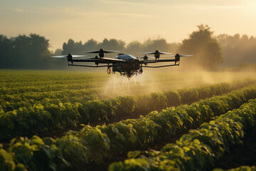
Increasing farm productivity while saving costs is challenging. But drones, also known as unmanned aerial vehicles (UAVs), help farmers overcome this hassle in an effective way.
Drones collect raw data which translates into useful information for farm monitoring. Drones equipped with cameras facilitate aerial imaging and surveying of near and far-stretched fields. This data optimizes the application of fertilizers, water,seeds, and pesticides. Moreover, drones along with GPS technology, are used for livestock tracking, geofencing, and grazing monitoring. They fly over fields to capture images that range from simple visible-light photographs to multispectral imagery which helps in the analysis of crop, soil, and field.
One drawback is they are not fit for poultry monitoring, as birds tend to get frightened by their movement. However, for others, like cattle or livestock monitoring, grazing monitoring,and crop cultivation, they are a cost-effective and invaluable tool for farmers to survey their lands. Startups are also working on drones capable of measuring the chlorophyll level, weed pressure, mineral and chemical composition of soils.
Wakan Tech is an Omani startup working on innovative drone solutions for aerial pollination of date palm trees. They develop drones for crop health monitoring, targeted spraying of pesticides and pollen. Their drones pollinate the trees by using liquid or dry pollen and are much faster than conventional pollination methods. These drones are equipped with AI and computer vision technology for the detection of pests
and diseased date palm trees. This allows faster and more accurate targeting and spraying, especially in the case of large farm operations.
Indian startup Equinox’s Drones leverages drone technology to offer numerous services like crop surveillance, aerial inspection, data processing, and data analysis. They provide
drone aerial mapping solutions with the help of ortho-mosaic maps, 3D point clouds, digital models, contour maps, and more. The startup processes images and videos from the
drones to facilitate aerial inspection of crops and data analysis. They also provide crop yield estimation based on the data acquired from drones.


